‘Paths are not just means of traversing space, but also of feeling, knowing and thinking.’
From the foreword by Robert Macfarlane in The Old Ways, A Journey on Foot
We are incredibly fortunate to have a huge network of paths in our area. The South Loch Ness Trail runs through the area but there is also a network of paths, some fairly well known, but others, which are less well known, perhaps not way marked and a little more off the beaten track. To encourage both locals and visitors to get out, explore, and have your own adventures, the pathways group have mapped and described a range of walks.
We will continue to add walks to the list below and if you are out on one of these walks and you find a shortcut or perhaps a variation that you think is better, please do let us know (and send us pics if you can!) Or, if you have your own favourite walks, get in touch and we can map them for you. Some of the best walks we have are those where literally you can’t see ‘the wood for the trees’.
Hillwalking during the deer stalking season? A link to help you find out where deer stalking is happening.
It is the responsibility of all walkers to take personal responsibility for their own safety on every walk and wear appropriate clothing and footwear for the conditions. When walking a route, you should not rely solely on a phone for navigation. Always take a map for backup. SFCT has tried to provide accurate information on the walks described but it cannot accept responsibility for changes, errors or omissions.
LIST OF WALKS
|
The link under each walk summary can be opened in the OS (Ordnance Survey) Maps app which is available to download free of charge. You can then follow the walk described and be confident you are not going off route at any time.
When looking at a walk, to quickly scroll back to the list above, click on the scroll to top button on the bottom right hand side of each walk. The Fair Haired Lad’s Pass (FHLP)The route described here is part of the South Loch Ness Trail (SLNT), starting at the forest carpark at Inverfarigaig, climbing over the FHLP and down to the B852 close to Dores. As this is a linear route, you will have to have two cars, leaving one at the end of the walk at the first big lay-by a couple of miles outside Dores, or time yourself to catch a bus back to the start. Or if you wish, the route can be extended by continuing on the SLNT all the way to Dores. 8.73 miles one way. Total ascent - 1321f. Mixture of minor roads and forest track. Difficulty: moderate https://explore.osmaps.com/route/28611518/fair-haired-lads-pass-slntrail
Park at the forest carpark in Inverfarigaig. Walk down to the B852 and follow the blue South Loch Ness Trail way markers by turning right and then right again after about 200m, on to the Corkscrew, a very minor tarred road. This spirals its way up before passing through open farmland. It’s a lovely area rich in history. On your right as you walk up the Corkscrew you look up to the lofty heights of Dun Dearduil. On the summit is the remains of an ancient bronze age fort. After following the road for approximately 2.5 miles it eventually begins to descend slightly. A short distance further you will see the way markers signalling you to turn left on to a forestry track. Follow this track towards the FHLP for a further mile following the blue way markers. Eventually the track flattens out and you will see a green forestry way marker pointing you in the direction of the FHLP. Half a mile on you reach the pass and the highest point on the trail with wonderful views across to Urquhart Castle, Loch Ness and beyond. The walk is worth it for this view alone! Once you’ve taken your selfie with the loch behind you, the path gets narrow and descends very steeply for about half a mile. Care needs to be taken here, as it can be slippy when conditions are wet. Look out for another SLNT way marker directing you to the right. Follow this as the scenery and more views open up over an area felled of trees. Soon you drop down on to a wide forestry road. Follow this as it runs parallel to the Loch and eventually descends right down to the B862. Turn left towards the lay-by to pick up your car, or if you want to extend the walk, turn right towards Dores.
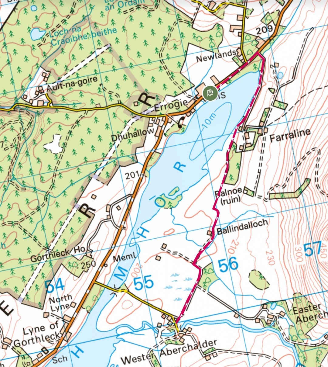
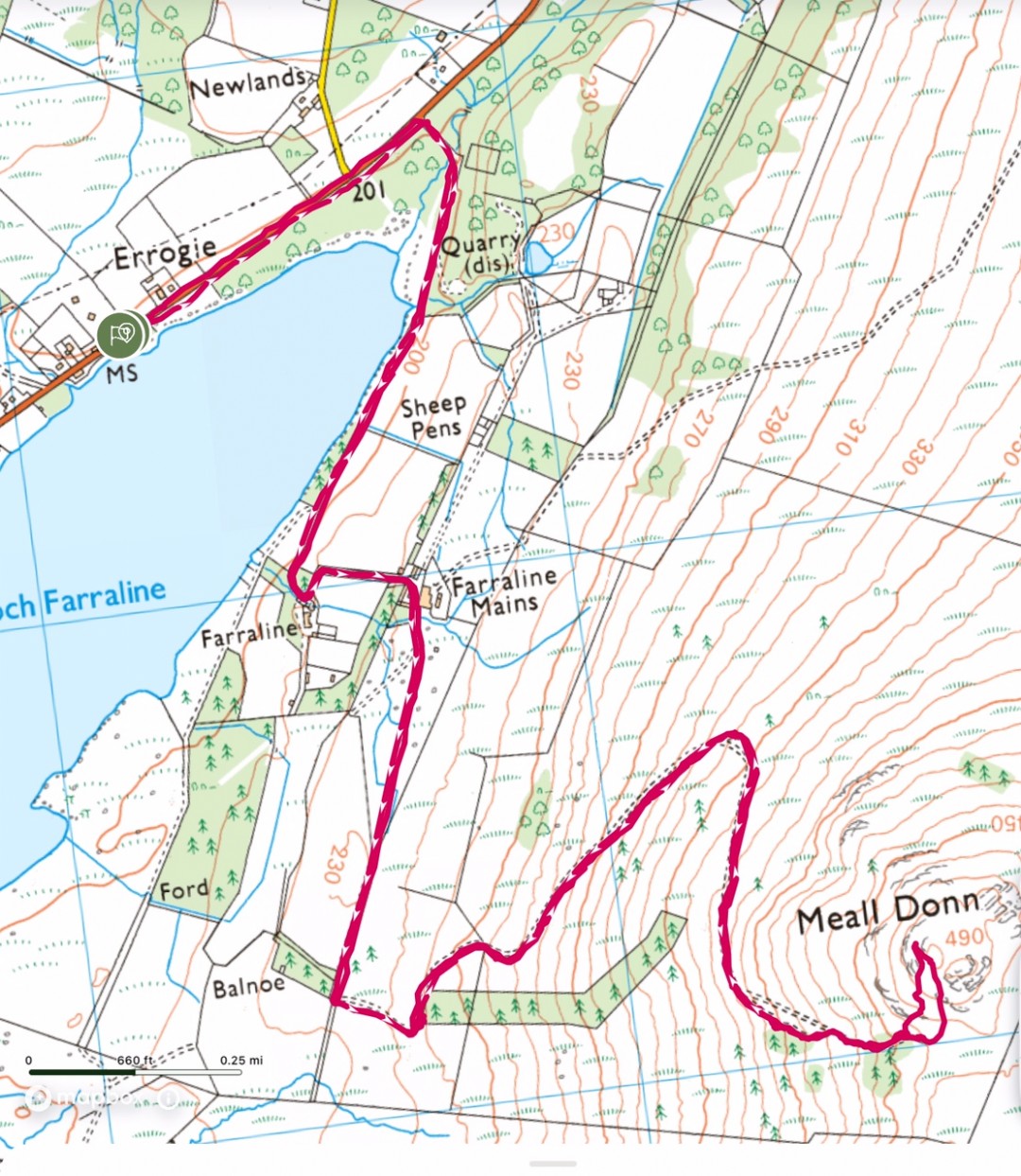
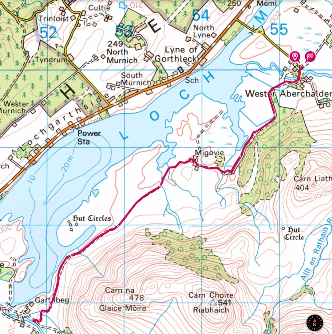
Errogie Church to Wester Aberchalder and returnA simple out and back route following minor roads and semi rough vehicle tracks with views across Loch Mhor and to Meall Donn. The start of the walk follows the same route as the walk up Meall Donn. Easy - 5.3 miles
Park at Errogie church and turn left towards Torness. At the junction marked Farraline Estate, turn right and follow the road along the side of Loch Mhor. Before the road bends up towards Farraline house there is a Trail of the Seven Lochs triangular marker on your right and a vehicle track with a gate. Follow the Trail of the Seven Lochs markers along this track, passing in front of a stone cottage, until you reach Wester Aberchalder. Look out for Ospreys and Red Kites along the route. To return to Errogie simply retrace your steps. This route can be followed as a simple out and return route as described above, or you may wish to consider two other options. The first makes this walk into a circular route, starting and finishing at Errogie. The second, if you have two cars would allow a longer linear walk from Errogie to Garthbeg. 1. On reaching Wester Aberchalder, turn right and walk past the houses on your left. When you reach the B862 turn right and simply follow this road all the way back to the starting point at Errogie Church. (4.95 miles) 2. On reaching Wester Aberchalder follow the Wester Aberchalder to Garthbeg route. (12.2miles)
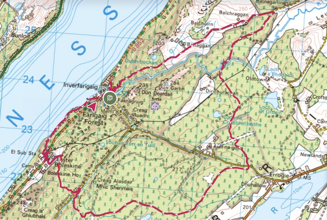
Inverfarigaig , Corkscrew, Errogie circularThis is a lovely circular route for not only walkers, but runners, cyclists and horse riders as well. A mixture of minor roads, forest roads and forest tracks provide variety for everyone. At a distance of just over 11 miles and over 1,500 feet of ascent, this is a great workout for all. Moderate
Starting at the Farigaig Forest car park in Inverfarigaig head down towards the junction with the B852. Turn right then right again opposite the new houses. This road is known as the Corkscrew - it heads steeply up hill in a series of zig zags before flattening out to a more gentle incline for approximately 2 miles. Finally, just past Balchraggan farm there is respite from the uphill as the road starts to descend slightly. At a sign saying ‘heavy vehicles crossing’ turn right onto the forest road (hard packed stone) and follow this for another 2 miles until you reach a junction with the Pass of Inverfarigaig minor road. Continue on the forest road for a further 2 miles until you cross a wooden bridge. Shortly after the bridge the road splits - stay to the right and continue for approx 1/4 mile until you see on the right, a blue Trail of the Seven Lochs way-marker. Take this narrow and rough path, following it downhill and eventually across a stream to the Glen Liath minor road. Turn right and continue for approx to a large turning area on your left. Follow the path on your left with the Right of Way marker - Foyers via hill route, Inverfarigaig via Boleskine, which initially goes fairly steeply uphill. After a short distance you will come to a wider track with a blue South Loch Ness Trail marker post and a Forestry finger post. Turn right here, following the track which, after a short way begins to head downhill. At the bottom of the track turn left and continue past a house (Easter Boleskine) and pond, down to the B852. Turn right for a short distance before hopping over a style on your left and onto a small tarred road which heads downhill towards the electricity sub-station. Look out for a wooden Forestry marker post on your right. The first part of this section is a little challenging and care is required to navigate some fallen trees before you reach a better path alongside Loch Ness. Follow this, passing a few houses until you reach Inverfarigaig Pier. Take the road heading uphill towards the B852.Turn left then right on the road signposted Errogie, back towards the start.
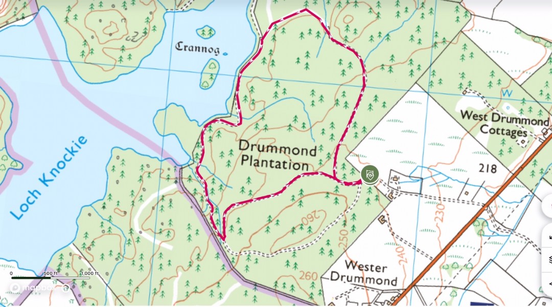
Drummond Plantation circular
|
|
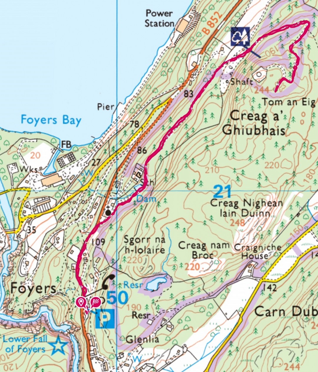
Inverfarigaig to Foyers, South Loch Ness Trail
3.2 miles, moderate
This walk follows a short section of the South Loch Ness Trail from Inverfarigaig to Foyers.
https://explore.osmaps.com/route/18306163/inverfarigaig-to-foyers-south-loch-ness-trail
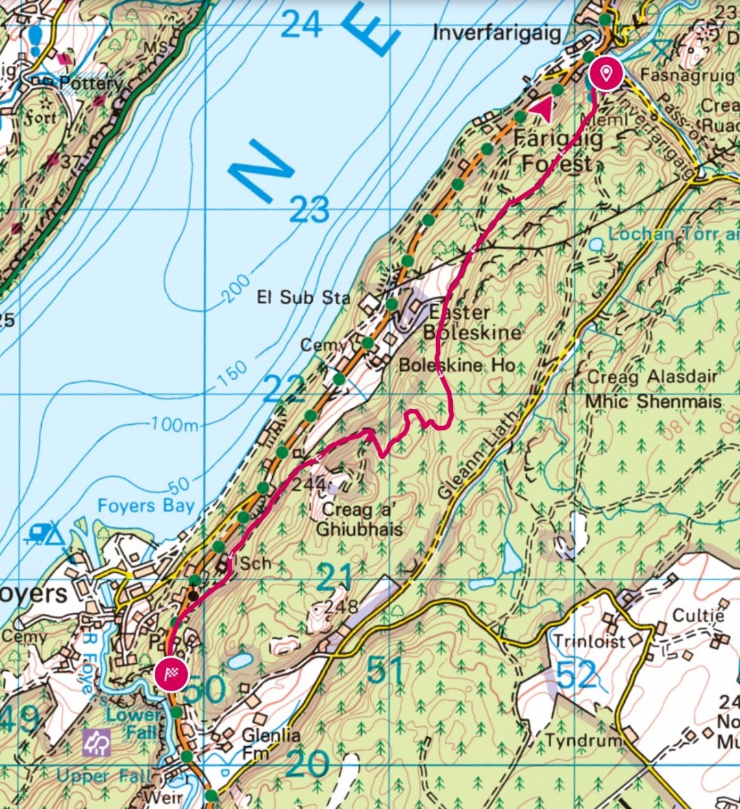
Description
Start the walk at the Farigaig car park. There is a short steep uphill section on a rough path to begin but turn right after about 50 metres to follow a small path to a viewpoint overlooking Loch Ness. If you are into Geocaching, you may want to search out the cache near here! Follow the route back down to the main forestry track. Turn right and look out for the blue marker posts with a squirrel which are the official signs for the South Loch Ness trail. When you reach the large pylons, it is worth making a very short diversion to the right to get views down to Foyers Bay. Continue on the forestry track, keeping left at a signpost marked for Easter Boleskine. Follow the track uphill, again, looking out for the blue marker posts. Keep straight ahead when you see a track on the left and follow this next section up into the trees.
Again look out for blue marker posts and be careful when you come to the chain to help you over a short rocky section. The track continues to wind uphill. Unfortunately, most of the views of Loch Ness have been obscured by trees, but there are a few big flat rocks which you can scramble onto for a peek at the loch or just sit and relax after the exertion of climbing to the highest point. The track now heads downhill, and after hopping across a wee burn, you come to a main forestry track again. Turn right here and follow this track all the way down to the main road B862. Be sure to look out for the shaft at a small clearing. This is a service tunnel of the Foyers Pump Storage Hydro scheme.
Turn left at the road and following the pavement, walk up the short sharp incline to the shop/car park at Foyers.
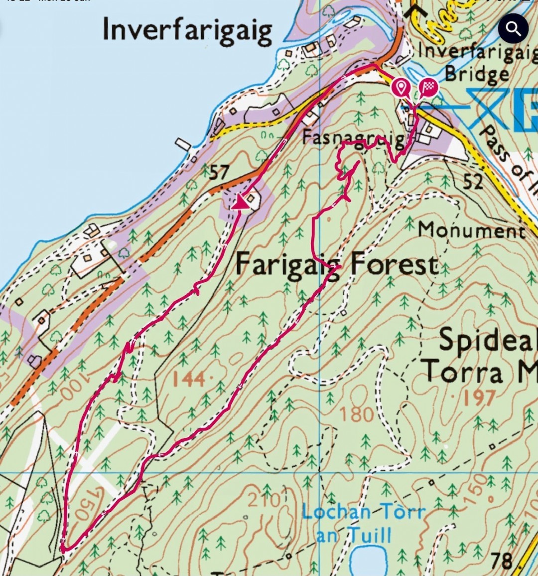
Inverfarigaig circular via Glen Liath
4.65 miles. Easy. Some road walking, with a couple of moderate sections
https://explore.osmaps.com/route/18306821/inverfarigaig-circular-via-glen-liath
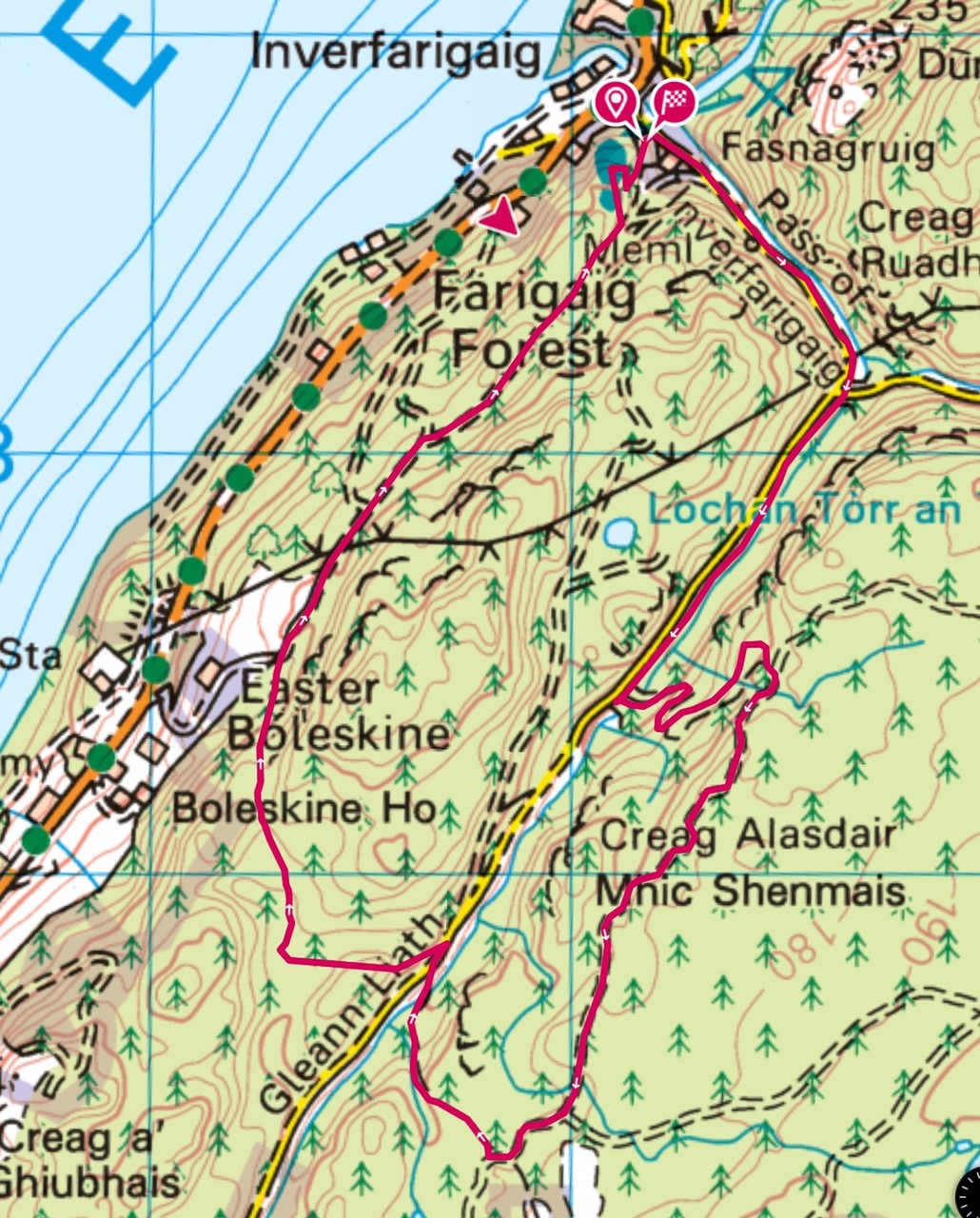 Description
Start the walk at the Farigaig car park.
From the car park, turn right along the road. Look out for the memorial to geologist James Bryce. Continue along the road and at the bridge, keep to the right along Glen Liath and look out for a Right of Way marker – Footpath to Aultnagoire and Stratherrick.
Take this track and follow an old but well defined path uphill until you reach a forestry road.
Turn right here and follow the road until it splits.
Keep to the right and look out for a Trail of the Seven Lochs blue marker post on your right. Take this small track which begins to head downhill and reaches the road again. At the road, turn right and you will reach a large turning area/forestry track. Look out for another Right of Way marker – Foyers via hill route, Inverfarigaig via Boleskine and take this track which initially goes fairly steeply uphill.
After a short distance you will come to a wider track with a blue South Loch Ness marker post and Forestry Finger Post. Turn right here, following the track which, after a short way, begins to head downhill. Keep to the right, following the blue markers until you are close to the car park. If you wish, you can follow a short loop to a lovely bench with views over Loch Ness.
If you are interested in Geocaching, you may want to search out the cache near here! Follow the track past the bench, heading steeply downhill to the car park.
Reservoir Walk, Foyers
Distance – 1.5 miles. A short circular walk to the old reservoir behind Foyers. A steep section up through the trees, and care needs to be taken when heading downhill back to the farm track at Glenlia. Easy/Moderate.
https://explore.osmaps.com/route/18798799/foyers-reservoir-circular
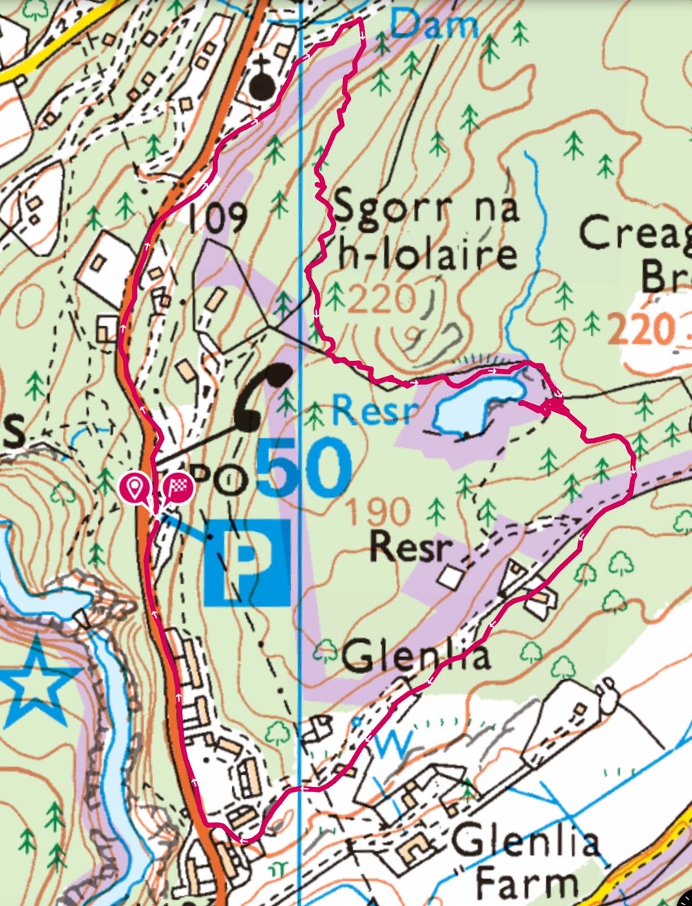 Description
Start at the car park at Foyers Stores and take the main road towards Inverfarigaig. Turn right up towards the school and follow the hill route to Inverfarigaig and Boleskine. At the gate, take the small track heading uphill. Just after two old tree stumps, take the route to the right, not uphill to the left.
Soon you will see the marker posts, this section can be boggy. Follow these uphill and then along the side of the reservoir. At the end of the reservoir, there is another marker post with a path leading to the left. Don’t take this immediately but follow the path you are on round to a large rock. If you are lucky and it is a still day, there will be wonderful reflections of the trees on the opposite bank in the water.
Retrace your steps and take the track at the marker post down through the trees where you will meet a vehicular track. Turn right here and follow this back towards Foyers, keeping left at the houses at Glen Liath. At the main road beside the playpark, turn right and return to the car park.
Foyers Circular including Upper Falls
Distance – 4 miles
A circular walk taking in both the upper and lower Falls of Foyers as well as the loch shore. Care should be taken on the narrow path after the Jane Fraser Memorial. Some climbing, especially up to the Lower Falls.
https://explore.osmaps.com/route/19123844/foyers-circular
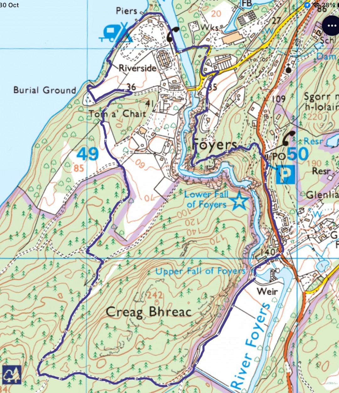 Description
From the Upper Foyers car park beside Foyers Stores and Waterfall Cafe, turn left towards Whitebridge.
Turn right at the Waterfall Cafe sign and follow the track to the narrow bridge. Stop here and have a look at the upper Falls of Foyers.
Continue over the bridge and take the track along the side of the fields. At the end of the fields, where the track splits, follow it up to the right (the left hand fork takes you to Whitebridge). The track rises for around quarter of a mile then it begins to go downhill again. Just past a bench, (which used to have wonderful views of Foyers Bay!) take a left along a smaller, grassy path. Go through the gate and, without turning left or right, cross straight over the field downhill towards a gap in the tree-line. Climb over the fence and follow the path through the woods and to the right towards the drive leading into Foyers cemetery. Turn left along this drive, go into the cemetery and then to your right, take the gate out of the cemetery. Head right towards the Jane Fraser memorial. Walk round the memorial, following a narrow path which will lead you down to the Loch shore. The Loch will be on your left. At the campsite follow the road up to the Bailey bridge and turn left across the bridge, following the road round as it goes towards upper Foyers. Take a right (opposite the Health Centre) where it is signed for Foyers Bay house and Foyers lodges.
Just at the entrance to Foyers Bay house, there is a track to the right. This track, which is steep in places, will lead you up through the woods with views of The Falls of Foyers and eventually to the main road, Foyers Stores and the car park.
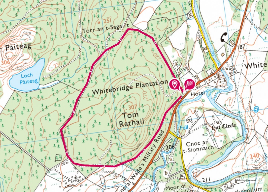
Whitebridge Plantation Circular
Distance - 2.6km circular route
This one is no doubt a well-travelled and well-known circular route that picks up an easy trail into Whitebridge Plantation. It is just along from the Whitebridge Hotel so grab a pre or post refreshment from the lovely team there!
Parking is a little limited, but the trail is good for all.
Please note that there are a lot of fallen trees blocking the grassy path about 2/3 of the way round. With a little care you can navigate over/round these.
https://explore.osmaps.com/route/18701545/drummond-woods-whitebridge
 Description
Park up just at the entrance (parking only for 1 car) or a suitable place along the road. Head off through the forestry gate and take the path straight ahead. Follow the path in an anti clockwise direction which meanders round on a level wide pathway suitable for walkers and bikes but then changes to a grassy track.
Keep your eyes peeled for deer, red kites, golden eagles and native woodlands, if you extend your walk to Loch Kemp.
Once complete, you can treat yourself to a coffee, cake or something stronger at the Whitebridge Hotel…just a few strides from the start of the walk. This easy and fairly level circular walk is a great accessible path with lovely views and peace amongst the woodland.
Loch Ness and the Falls of Foyers
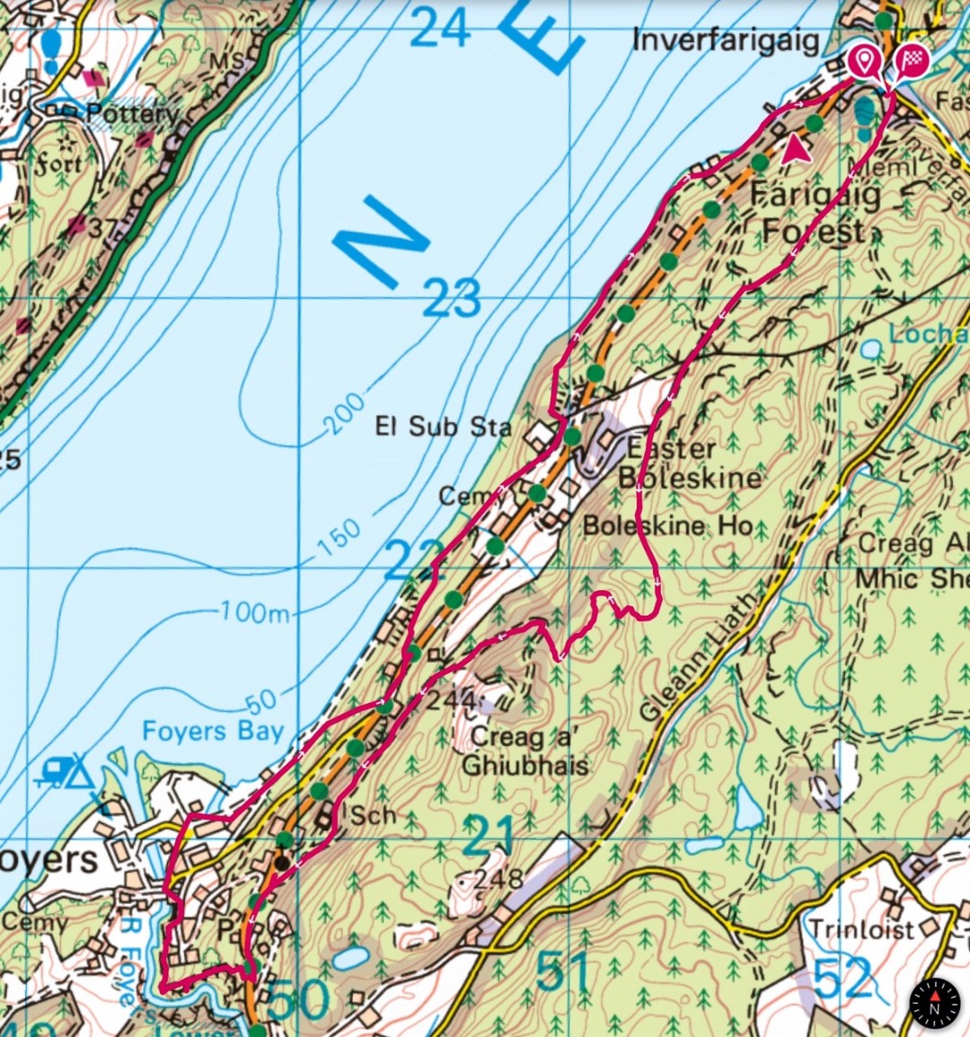
This is a moderate walk of 6.1 miles starting from the car park at Farigaig Forest, climbing to Toman Tarsuinn before reaching the halfway point in the village of Foyers. Stop here for a breather and bite to eat at the Waterfall Café or simply take advantage of the toilets in the car park area.
https://explore.osmaps.com/route/18701694/loch-ness-and-falls-of-foyers
 Description
Start at the Farigaig Forest car park and head steeply uphill on a rough path for a short distance before turning right on a track which will take you around a small loop to a viewpoint overlooking Loch Ness. If you are interested in geocaching you may wish to have a hunt for the cache near the bench!
After the bench continue following the narrow but well defined path through the trees which will eventually take you down to a main forestry track. Turn right here and look out for the blue South Loch Ness trail marker posts. When you reach the large pylons, take a short diversion to the right to get a wonderful view of Meall Fuar-mhonaidh, the highest point round Loch Ness, and Foyers Bay. Continue on the main track until you come to a junction where you keep left and follow the track up a fairly steep slope through the trees until you get to Forestry Commission fingerpost and a South Loch Ness Trail blue marker. Continue straight ahead here through a fairly boggy section and up through the trees.
Again, lookout for blue marker posts and be careful when you come to the chain to help you over a short rocky section. The track continues to wind up hill. Unfortunately most of the views of Loch Ness have been obscured by trees but there are a few big flat rocks which you can scramble onto for a peak of the Loch or just sit and relax after the exertion of climbing to the highest point of Toman Tarsuinn. The track now heads downhill and after hopping across a wee burn you come to a main forestry track again. Turn right here and follow this track all the way down to the main road, B852. Be sure to look out for the shaft in a small clearing. This is a service tunnel of the Foyers pump storage Hydro scheme.
Turn left at the road and following the pavement walk the short, sharp incline to the shop, and Waterfall café in Foyers. Cross the road and follow the track signposted Upper Falls of Foyers. The falls are often spectacular but not so much after a dry spell or if SSE are drawing water off for hydroelectricity purposes. Retrace your steps before following the path round the gorge and through the trees before coming out on a track which leads to Foyers Bay House hotel. Turn left on this track downhill to the road to Lower Foyers. Turn left on this road and follow it around a right hand bend past some recycling bins and one of the Foyers to Inverness bus stops. A short way down the road on a left hand bend take the right hand turning towards the SSE power station. After the large stone building on the right (the old Foyers Aluminium Smelting factory) and opposite the boat yard, turn right onto a track with a green marker post. When the track bends to the right, take the left fork and you will soon see some very old and rickety wooden steps. Pass these and walk steadily uphill until you reach the B852 where you turn left. About halfway up this track there is a delightful wooden bench with a quirky description.
Walk along the road past Foyers Lodge hotel and just past the hotel you will see a metal fence on your left with a green Right of Way sign directing you towards Inverfarigaig via loch side route. Take this path down a steep set of steps and into woodland. Turn right, take a stile over the metal fence and continue downhill through the woods until you reach a tarmac road which is the service road for the SSE power station. Turn right on this road until you come to an SSE substation. Immediately past the substation you will see a marker post and track with some steps that lead you downhill back into woodland. As the track bends to the right, there are a lot of fallen trees ahead. To avoid these walk about 15 metres then look out for a very vague track on your right. Follow this into the woods (but don’t start climbing) and you’ll see an old grass covered forestry track. Follow this until you see a way marker and the main track again. This alternative route is only about 100m. Continue on this wider route grassy path which continues all the way to Lower Birchwood.
Opposite the track to Lower Birchwood there is a small track on your left. Follow this down to the loch shore where you will find a number of seats where you can enjoy the views over the loch. Return to the main track and follow this past a number of houses to Inverfarigaig pier. This is an old Thomas Telford pier, most of which is still intact but the Victorian addition at the end has unfortunately fallen into complete disrepair. Enjoy the view across to Meall Fuar-mhonaidh and up the loch towards Urquhart Castle. Follow the tarmac road up to the B852 where you turn left and then right at the junction signposted for Errogie and return to the car park.
Lochan Tor an Tuill circular from Inverfarigaig
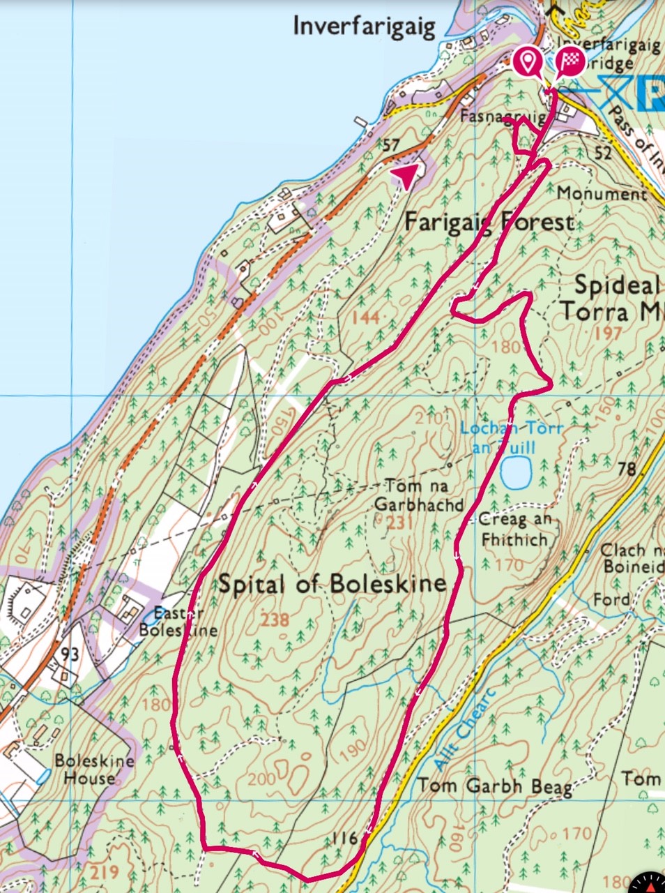
This is a varied 3.65 mile circular route with three viewpoints which give wonderful views of Loch Ness. The route is mostly on wide forestry tracks with three moderate to steep uphill sections.
https://explore.osmaps.com/route/18788107/lochan-tor-an-tuill-circular
 Description
Start at the Farigaig forest car park and follow the rough track which rises steeply uphill. Pass the sign for a viewpoint (you’ll take this in on your return) and the track widens. Take the track to the left and admire the huge fir trees along the burn. Follow this route until it levels off and you come to the first view of Loch Ness. Continue on the track, which now heads downhill, until just before Lochan Tor an Tuill. At the Forestry Finger post, you can make a short but steep diversion, turning right and following forestry marker posts to a viewpoint with excellent views of Meall Fuar-mhonaidh to the southwest, Urquhart Castle to the northeast and the imposing bluff of Dun Dearduill, where there are vitrified remains of a Bronze Age fort. Retrace your steps and continue to Lochan Tor an Tuill.
The wide track past Tor an Tuill gives you views of the road going through Glen Liath as you head downhill to a gate and the road itself. Follow the track steeply uphill signed with a Right of Way marker – Foyers via hill route, Inverfarigaig via Boleskine.
After a short distance you will come to a wider track with a blue South Loch Ness Trail marker post and Forestry Finger post. Turn right here, following the track which, after a short way begins to head downhill. Keep to the right following the blue markers until you are close to the car park. Take a left, following Forestry marker posts on a short loop to a bench with views over Loch Ness.
If you are interested in Geocaching, you may want to search out the catch near the bench! Beyond the bench, follow the track which heads fairly steeply downhill to the car park.
Whitebridge to Foyers and return or Foyers to Whitebridge return
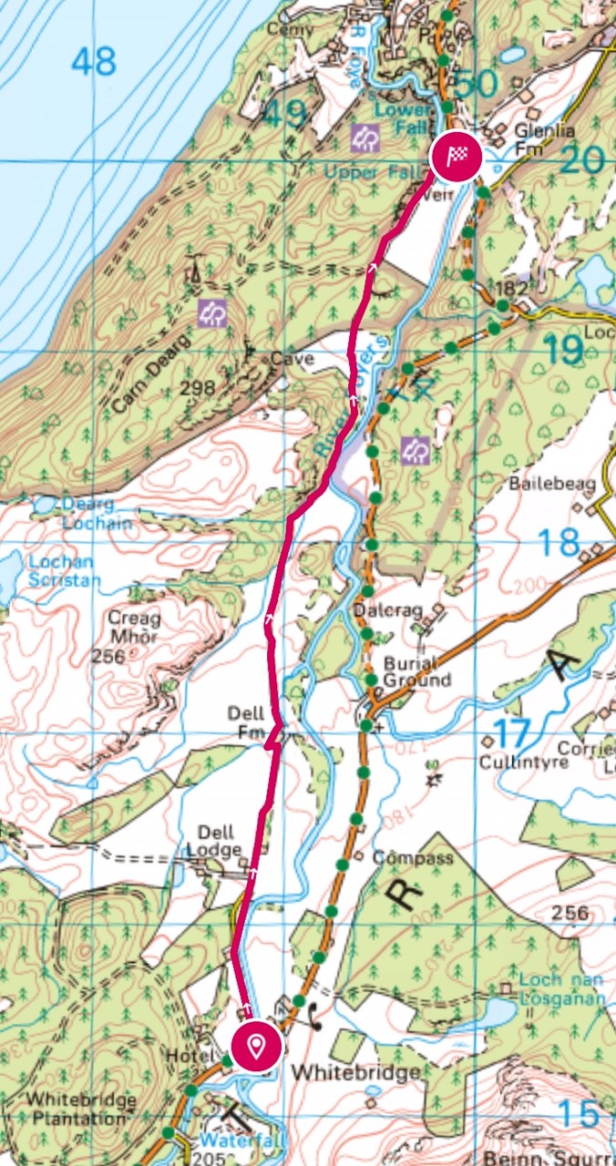
This can be walked from either Whitebridge or Foyers or from Foyers to Whitebridge. It is part of the South Loch Ness trail and there are blue way markers along the route. The route is flat but there are a couple of stream crossings with large stepping stones.
Return 7.0 miles
Easy.
Start point – either the Whitebridge bus stop/end of Dell Estate road or the Falls of Foyers car park.
https://explore.osmaps.com/route/20615341/whitebridge-to-foyers-and-return
 Description Whitebridge to Foyers and return
From the bus stop, take the road, then track towards Dell Farm. Just before the farm, turn left at the blue way marker beside a large barn and then turn right, following the fence until you join a vehicular track. Soon it becomes a very pleasant grassy track and continues beside an old stone wall. Take care crossing the two streams. Continue on this track unto you see another track on your left heading uphill. Ignore this, continuing straight ahead until you reach a small stone bridge. Walk over the bridge and have a look at the Upper Falls of Foyers. At the road, turn left past the play park until you reach the car park, toilets, Foyers Stores and Waterfall Café. Alternatively at the road turn right towards Camerons Tearoom. Simply retrace your steps to return to Whitebridge.
Description Foyers to Whitebridge and return
From the car park turn left towards Whitebridge, pass the play park and then turn right at the Waterfall Café sign and follow the track to the stone bridge. Stop here and have a look at the Upper Falls of Foyers. Continue over the bridge and take the grassy track along the side of the fields. At the end of the fields where the track splits, go straight ahead. Follow the grassy track, taking care crossing the two streams. When you reach the farm, keep to the right walking round the barn and then turn right onto the vehicular track. Follow the track/road all the way to Whitebridge. Turn right towards the Whitebridge Hotel for a well earned cuppa before retracing your steps back to Foyers.


 Description
 Description
 Description
 Description
.jpg) Description
Description Description
 Description
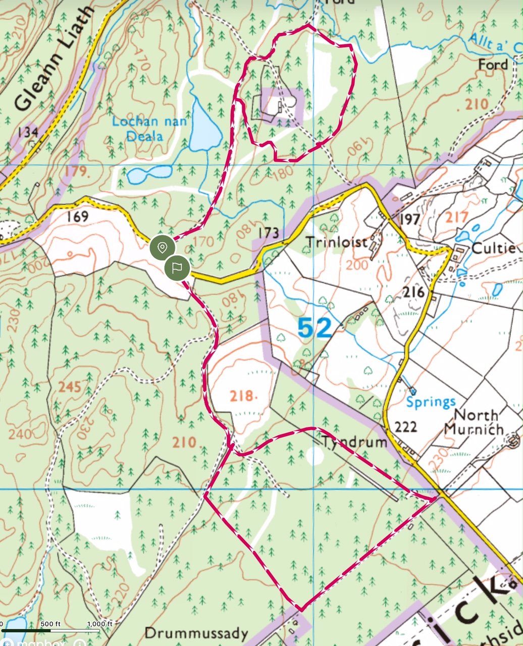 Forest circuit taking in part of The Vennel
 Description
 Description
 Description
 Description
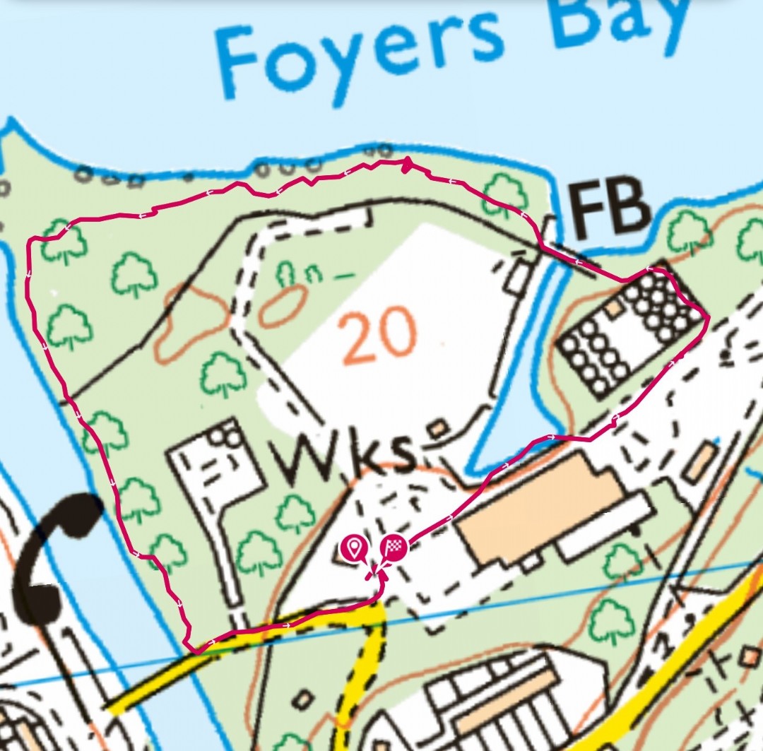 Description
 Stratherrick & Foyers Community Trust,